Strzyżów Foothills
6.55
Overview
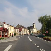
The Strzyżów Foothills is a mesoregion located in southern Poland, forming part of the Central Beskid Foothills. Its highest peak is Bardo, reaching an elevation of 534 meters above sea level. The region features diverse topography, bordered to the south by the Jasło-Krosno Basin, and on other sides by the Ciężkowice Foothills, Dynów Foothills, and the Subcarpathian Pradolina. Covering an area of approximately 900 km², the Strzyżów Foothills include the Czarnorzecko-Strzyżowski Landscape Park, renowned for its rich flora and fauna as well as stunning landscapes.
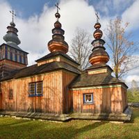
Architecturally, the region is rich in historical landmarks, such as the Church of St. Nicholas in Brzeziny, which undoubtedly attracts both tourists and history enthusiasts. Another notable site is the monument to Tadeusz Kantor in Wielopole, unveiled in 2015, which pays tribute to the renowned Polish director and artist while also serving as an element of local culture and art. The region also offers new tourist opportunities, such as the observation tower and Jurapark in Głobikowa, perfect for admiring picturesque views and exploring the area’s geological secrets.
The Strzyżów Foothills are not only a place of natural beauty but also a region rich in history and culture. It preserves its traditions, making it an intriguing destination for tourists interested in local customs and history. Additionally, attractions such as landscape parks and numerous hiking trails promote active recreation, making the area appealing to nature lovers. In summary, the Strzyżów Foothills is a destination that combines natural beauty, rich cultural heritage, and attractive tourist offerings.
Location


2026 Wizytor | All Rights Reserved